
Dime Hill topographic map
Interactive map
Click on the map to display elevation.
About this map
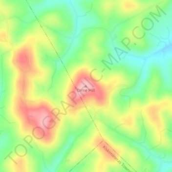
Name: Dime Hill topographic map, elevation, terrain.
Average elevation: 365 m
Minimum elevation: 302 m
Maximum elevation: 441 m
Other topographic maps
Click on a map to view its topography, its elevation and its terrain.
Orchard Hills
United States > Pennsylvania > Armstrong County > Kiskiminetas Township
Average elevation: 347 m
Leechburg
United States > Pennsylvania > Armstrong County
Leechburg is located at 40°37′45″N 79°36′13″W / 40.62917°N 79.60361°W / 40.62917; -79.60361 (40.629304, -79.603727). Elevations range from 780 feet (240 m) to 1,080 feet (330 m) above sea level.
Average elevation: 287 m