
Toranzo topographic map
Interactive map
Click on the map to display elevation.
About this map
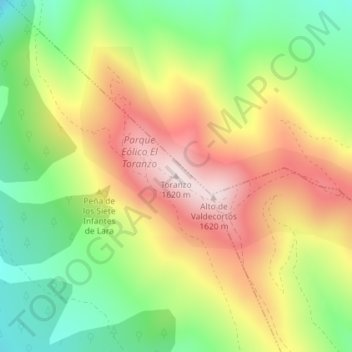
Name: Toranzo topographic map, elevation, terrain.
Location: Toranzo, Soria, Castilla y León, España (41.71838 -1.93047 41.71848 -1.93037)
Average elevation: 1,385 m
Minimum elevation: 1,174 m
Maximum elevation: 1,620 m
Other topographic maps
Click on a map to view its topography, its elevation and its terrain.
Embalse de la Cuerda del Pozo
España > Castilla y León > Soria
Embalse de la Cuerda del Pozo, Carretera de Salas de los Infantes a Abejar, Soria, Comarca de Pinares, Soria, Castilla y León, 42156, España
Average elevation: 1,130 m