
Make a donation
Gear up for your next adventure:
As an Amazon Associate, this site earns from qualifying purchases at no extra cost to you.
Hodgen topographic map
Click on the map to display elevation.
Make a donation
Gear up for your next adventure:
As an Amazon Associate, this site earns from qualifying purchases at no extra cost to you.
About this map
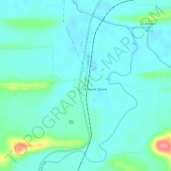
Name: Hodgen topographic map, elevation, terrain.
Location: Hodgen, LeFlore County, Oklahoma, United States (34.82177 -94.65134 34.86177 -94.61134)
Average elevation: 166 m
Minimum elevation: 149 m
Maximum elevation: 241 m
Make a donation
Gear up for your next adventure:
As an Amazon Associate, this site earns from qualifying purchases at no extra cost to you.
Other topographic maps
Click on a map to view its topography, its elevation and its terrain.
Poteau
United States > Oklahoma > LeFlore County
The city is located in the valley below Cavanal Hill, dubbed the "World's Highest Hill" with a signed elevation of 1,999 feet (609 m). The location was a subject of extensive coal mining in the first half of the 20th Century, and a railway, eventually called the Poteau and Cavanal Mountain Railroad, served the…
Average elevation: 189 m
Make a donation
Gear up for your next adventure:
As an Amazon Associate, this site earns from qualifying purchases at no extra cost to you.
Poteau
United States > Oklahoma > LeFlore County
The city is located in the valley below Cavanal Hill, dubbed the "World's Highest Hill" with a signed elevation of 1,999 feet (609 m). The location was a subject of extensive coal mining in the first half of the 20th century, and a railway, eventually called the Poteau and Cavanal Mountain Railroad, served the…
Average elevation: 189 m
Make a donation
Gear up for your next adventure:
As an Amazon Associate, this site earns from qualifying purchases at no extra cost to you.
Poteau
United States > Oklahoma > LeFlore County
The city is located in the valley below Cavanal Hill, dubbed the "World's Highest Hill" with a signed elevation of 1,999 feet (609 m). The location was a subject of extensive coal mining in the first half of the 20th Century, and a railway, eventually called the Poteau and Cavanal Mountain Railroad, served the…
Average elevation: 189 m