
The Green Park topographic map
Interactive map
Click on the map to display elevation.
About this map
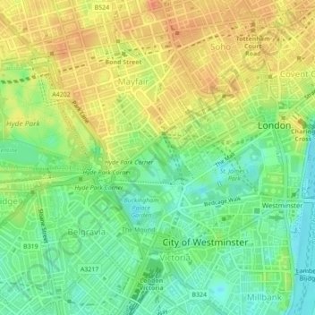
Name: The Green Park topographic map, elevation, terrain.
Average elevation: 22 m
Minimum elevation: 1 m
Maximum elevation: 43 m
Other topographic maps
Click on a map to view its topography, its elevation and its terrain.
Greenwich
Reino Unido > Inglaterra > Londres
Greenwich, Londres, Greater London, Inglaterra, SE10 9HF, Reino Unido
Average elevation: 20 m
Lewisham
Reino Unido > Inglaterra > Londres > Lewisham
Lewisham, Londres, Greater London, Inglaterra, SE13 6BB, Reino Unido
Average elevation: 28 m
Brentford Ait
Reino Unido > Inglaterra > Londres
Brentford Ait, Richmond-upon-Thames, Londres, Greater London, Inglaterra, Reino Unido
Average elevation: 11 m