Geolocate

Ferndale topographic map

Click on the map to display elevation.

About this map

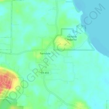
Name: Ferndale topographic map, elevation, terrain.

Location: Ferndale, Lake County, Florida, 34729, United States (28.60564 -81.71652 28.63750 -81.68265)

Average elevation: 28 m

Minimum elevation: 15 m

Maximum elevation: 69 m

Gear up for your next adventure:

🧥Waterproof Hiking Jackets - Rain protection for walking in all weather conditions
🐕Dog Hiking Gear - Equipment for hiking safely with dogs
🧗Locking Carabiners - Secure gear to your pack or for light technical use
🍳Camping Stoves - Compact stoves for outdoor cooking
Insulated Travel Mugs - Keep drinks hot while surveying the landscape from a summit

As an Amazon Associate, this site earns from qualifying purchases at no extra cost to you.