
Make a donation
Nevado de Cachi topographic map
Interactive map
Click on the map to display elevation.


Nevado de Cachi
Nevado de Cachi is the name given to a large complex of mountains that lies in Salta Province, Argentina. This complex counts several summits, the highest being 6,380m and it is called Cumbre Libertador. This summit was climbed for the first time in 1950. The mountains overlook Cachi, a traditional village of Northern Argentina. The main summit is rarely climbed (less than 5 expeditions per year) and the secondary summits even less. Some of them have been climbed only once. The mountain can be climbed, in favourable weather conditions, in five days by a party fully acclimatised to an altitude of 4,000m. The quality of the rock is almost everywhere poor, there is permanent snow but almost no glacier. Climbing interest is little but the area is of outstanding beauty. Almost all routes are easy but rockfalls are common. In summer the snow-line is about at 5,800m; in winter it is significantly lower (as low as 3,500m) making possible some technical climbs (ice and snow route at about 55 degrees). The region experiences the same seasons of Bolivia, summers are dry but winter can be very rainy with heavy snowfalls. Wind is probably the main hazard and should be not underestimated.
About this map
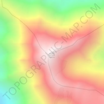
Name: Nevado de Cachi topographic map, elevation, terrain.
Average elevation: 5,900 m
Minimum elevation: 5,197 m
Maximum elevation: 6,348 m
Other topographic maps
Click on a map to view its topography, its elevation and its terrain.
Municipio de San Antonio de los Cobres
The town is known for its high elevation of approximately 3,775 meters (12,385 feet) above sea level, being one of the highest elevations of any city or town in Argentina. It is located approximately 160 kilometers (99 mi) from the city of Salta and 2,000 kilometers (1,200 mi) from the capital, Buenos Aires.…
Average elevation: 3,733 m
Monumento Natural del Abra del Acay
The Abra del Acay in La Poma Department, Salta Province, Argentina is the highest point on Argentina's National Route 40. Located at 24°23′S 66°14′W / 24.383°S 66.233°W / -24.383; -66.233, its altitude is 4,972 meters (16,312 ft), even though an old sign informs visitors it stands at 4,895…
Average elevation: 4,291 m