
Balkh Province topographic map
Interactive map
Click on the map to display elevation.
About this map
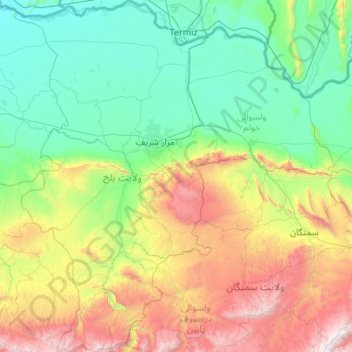
Name: Balkh Province topographic map, elevation, terrain.
Location: Balkh Province, Afghanistan (35.67117 66.25143 37.39849 68.20466)
Average elevation: 1,011 m
Minimum elevation: 262 m
Maximum elevation: 3,802 m
Other topographic maps
Click on a map to view its topography, its elevation and its terrain.
Mazar-i-Sharif
Mazar-i-Sharif, Balkh Province, 1701, Afghanistan
Average elevation: 367 m
Kishindih
Kishindih, Balkh Province, Afghanistan
Average elevation: 1,576 m