Geolocate

Birdbrook topographic map

Click on the map to display elevation.

About this map

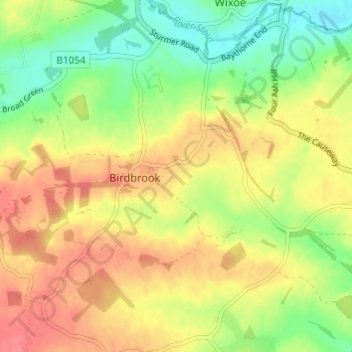
Name: Birdbrook topographic map, elevation, terrain.

Location: Birdbrook, Braintree, Essex, England, United Kingdom (52.02265 0.47207 52.06000 0.53030)

Average elevation: 80 m

Minimum elevation: 49 m

Maximum elevation: 107 m

Essex trails, hiking, mountain biking, running and outdoor activities

Gear up for your next adventure:

Lightweight Solo Tents - Backpacking tents designed for wild camping in the UK highlands
🥾Women's Waterproof Hiking Boots - High-performance trekking boots designed for all-weather comfort
🧴Sport Sunscreen Sticks - High-protection sunblock that won't run into your eyes on the trail
📸Action Camera Chest Mounts - Record your ascent following topographic paths hands-free
👖Packable Overtrousers - Quick-deploy rain protection for legs in sudden storms

As an Amazon Associate, this site earns from qualifying purchases at no extra cost to you.