
Mù Cang Chải District topographic map
Interactive map
Click on the map to display elevation.
About this map
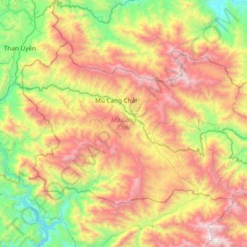
Name: Mù Cang Chải District topographic map, elevation, terrain.
Location: Mù Cang Chải District, Yen Bai Province, Vietnam (21.64259 103.88624 21.96680 104.41705)
Average elevation: 1,277 m
Minimum elevation: 137 m
Maximum elevation: 2,938 m
Mù Cang Chải is a landlocked district that borders Van Ban district of Lao Cai province to the north, Muong La district of Son La province to the south, Than Uyen of Lai Chau province to the west, and Van Chan district of Yen Bai province to the east. The district is located at the foot of Hoang Lien Son mountain range, at an altitude of 1,000 m above sea level. To get to Mù Cang Chải district, travellers must pass through Khau Phạ Pass, which is one of four imposing passes in northwest Vietnam.
Other topographic maps
Click on a map to view its topography, its elevation and its terrain.
Yên Bình District
Yên Bình District, Yên Bái Province, Vietnam
Average elevation: 130 m
Thác Bà
Vietnam > Yen Bai Province > Yên Bình District > Thác Bà
Thác Bà, Yên Bình District, Yen Bai Province, Vietnam
Average elevation: 71 m
Mù Cang Chải
Vietnam > Yen Bai Province > Mù Cang Chải District
Mù Cang Chải, Mù Cang Chải District, Yên Bái Province, Vietnam
Average elevation: 1,421 m
Ngã Ba Kim
Vietnam > Yen Bai Province > Ngã Ba Kim
Ngã Ba Kim, Mù Cang Chải District, Yen Bai Province, Vietnam
Average elevation: 1,258 m