Geolocate

Manoka topographic map

Click on the map to display elevation.

About this map

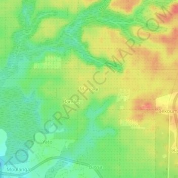
Name: Manoka topographic map, elevation, terrain.

Location: Manoka, Dibombari, Moungo, Littoral, Cameroon (4.14445 9.54712 4.18445 9.58712)

Average elevation: 27 m

Minimum elevation: -2 m

Maximum elevation: 57 m

Gear up for your next adventure:

Lightweight Tents - Compact tents for backpacking and trekking
🔪Outdoor Multi-Tools - Versatile tools for gear repairs and food prep in the wild
🔦Keychain LED Torches - Emergency backup light for finding gear in your pack
🧥Waterproof Hiking Jackets - Rain protection for walking in all weather conditions
🔋Solar Power Banks - Keep your GPS and phone charged during multi-day expeditions

As an Amazon Associate, this site earns from qualifying purchases at no extra cost to you.