Geolocate
Thank you for supporting this site ❤️Make a donation

Piti Municipality topographic map

Click on the map to display elevation.

About this map

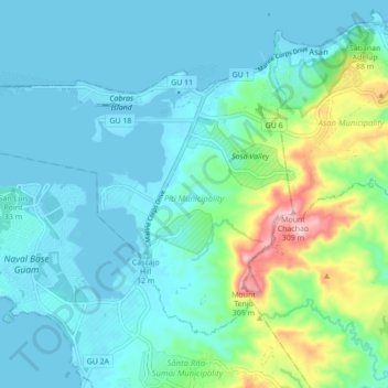
Name: Piti Municipality topographic map, elevation, terrain.

Location: Piti Municipality, Guam, United States of America (13.41043 144.62396 13.47170 144.71090)

Average elevation: 57 m

Minimum elevation: -1 m

Maximum elevation: 312 m

Other topographic maps

Click on a map to view its topography, its elevation and its terrain.

Guam

United States of America

Guam, United States of America

Average elevation: 16 m

In order to remain free and to keep improving, this site uses cookies created by Google to compile visit statistics and display personalized advertisements.

How is the collected data used?