
Thank you for supporting this site ❤️
Make a donation
Make a donation
Gear up for your next adventure:
As an Amazon Associate, this site earns from qualifying purchases at no extra cost to you.
Gschnitztal topographic map
Click on the map to display elevation.
Thank you for supporting this site ❤️
Make a donation
Make a donation
Gear up for your next adventure:
As an Amazon Associate, this site earns from qualifying purchases at no extra cost to you.
About this map
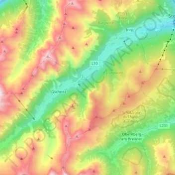
Name: Gschnitztal topographic map, elevation, terrain.
Location: Gschnitztal, Trins, Bezirk Innsbruck-Land, Tyrol, Austria (47.00809 11.29562 47.09403 11.46622)
Average elevation: 1,829 m
Minimum elevation: 989 m
Maximum elevation: 3,090 m
Thank you for supporting this site ❤️
Make a donation
Make a donation
Gear up for your next adventure:
As an Amazon Associate, this site earns from qualifying purchases at no extra cost to you.