
Brixworth topographic map
Click on the map to display elevation.
About this map
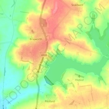
Name: Brixworth topographic map, elevation, terrain.
Location: Brixworth, West Northamptonshire, England, United Kingdom (52.30201 -0.92951 52.34682 -0.85332)
Average elevation: 105 m
Minimum elevation: 69 m
Maximum elevation: 145 m
West Northamptonshire trails, hiking, mountain biking, running and outdoor activities
Other topographic maps
Click on a map to view its topography, its elevation and its terrain.
Lower Thorpe
United Kingdom > England > West Northamptonshire > Thorpe Mandeville
Average elevation: 154 m
Ravensthorpe Reservoir
United Kingdom > England > West Northamptonshire > Coton
Average elevation: 131 m