Geolocate

Latchingdon topographic map

Click on the map to display elevation.

About this map

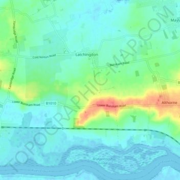
Name: Latchingdon topographic map, elevation, terrain.

Location: Latchingdon, Maldon, Essex, England, United Kingdom (51.63254 0.69903 51.68729 0.76765)

Average elevation: 12 m

Minimum elevation: -3 m

Maximum elevation: 55 m

England trails, hiking, mountain biking, running and outdoor activities

Other topographic maps

Click on a map to view its topography, its elevation and its terrain.

Ulting

United Kingdom > England > Maldon > Ulting

Average elevation: 30 m

Gear up for your next adventure:

👟Waterproof Leg Gaiters - Keep mud and water out of your boots in boggy terrain
🎿Telescopic Trekking Poles - Reduces knee strain on steep topographic descents
🦯Walking Poles - Supportive poles for long-distance walking
🧥Packable Down Jackets - Lightweight warmth that compresses small in your bag
🧼Camping Hygiene Kits - Compact hygiene essentials for outdoor stays

As an Amazon Associate, this site earns from qualifying purchases at no extra cost to you.