Geolocate

Lido topographic map

Click on the map to display elevation.

About this map

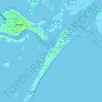
Name: Lido topographic map, elevation, terrain.

Location: Lido, Venice, Venezia, Veneto, 30132, Italy (45.37646 12.33061 45.45646 12.41061)

Average elevation: 0 m

Minimum elevation: -6 m

Maximum elevation: 14 m

Other topographic maps

Click on a map to view its topography, its elevation and its terrain.

Canal Grande

Italy > Veneto > Venezia > Venice > Lido

Average elevation: 2 m

Murano

Italy > Veneto > Venezia > Venice > Murano

Average elevation: 0 m

Burano

Italy > Veneto > Venezia > Venice > Burano

Average elevation: 0 m

Sant'Erasmo

Italy > Veneto > Venezia > Venice > Sant'Erasmo

Average elevation: 0 m

Gear up for your next adventure:

🧼Camping Hygiene Kits - Compact hygiene essentials for outdoor stays
🧗Locking Carabiners - Secure gear to your pack or for light technical use
🚲Bikepacking Frame Bags - Storage for tools and navigation gear on long off-road rides
🧼Biodegradable Soap - Leave-no-trace hygiene for multi-day mountain treks
🔦LED Camping Lanterns - Illumination for reading maps inside your tent at night

As an Amazon Associate, this site earns from qualifying purchases at no extra cost to you.