
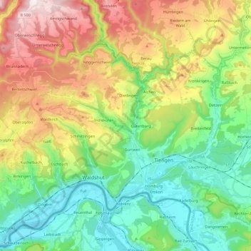
Waldshut-Tiengen topographic map
Interactive map
Click on the map to display elevation.
About this map
Name: Waldshut-Tiengen topographic map, elevation, terrain.
Average elevation: 553 m
Minimum elevation: 301 m
Maximum elevation: 1,007 m
Other topographic maps
Click on a map to view its topography, its elevation and its terrain.
Mättle
Germany > Baden-Württemberg > Landkreis Waldshut > Todtmoos
Mättle, Todtmoos, Verwaltungsverband St. Blasien, Landkreis Waldshut, Baden-Württemberg, 79682, Germany
Average elevation: 1,001 m
Spießhorn
Germany > Baden-Württemberg > Landkreis Waldshut
Spießhorn, Bernau im Schwarzwald, Verwaltungsverband St. Blasien, Landkreis Waldshut, Baden-Württemberg, 79872, Germany
Average elevation: 1,123 m
Bad Säckingen
Germany > Baden-Württemberg > Landkreis Waldshut
Bad Säckingen, Verwaltungsgemeinschaft Bad Säckingen, Landkreis Waldshut, Baden-Württemberg, 79713, Germany
Average elevation: 438 m
Bonndorf im Schwarzwald
Germany > Baden-Württemberg > Landkreis Waldshut
Bonndorf im Schwarzwald, Verwaltungsgemeinschaft Bonndorf im Schwarzwald, Landkreis Waldshut, Baden-Württemberg, 79848, Germany
Average elevation: 797 m
Niedergebisbach
Germany > Baden-Württemberg > Landkreis Waldshut > Niedergebisbach
Niedergebisbach, Herrischried, Verwaltungsgemeinschaft Bad Säckingen, Landkreis Waldshut, Baden-Württemberg, 79737, Germany
Average elevation: 872 m