
Make a donation
Gear up for your next adventure:
As an Amazon Associate, this site earns from qualifying purchases at no extra cost to you.
Spießhorn topographic map
Click on the map to display elevation.
Make a donation
Gear up for your next adventure:
As an Amazon Associate, this site earns from qualifying purchases at no extra cost to you.
About this map
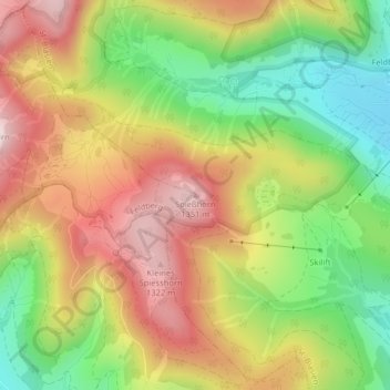
Name: Spießhorn topographic map, elevation, terrain.
Average elevation: 1,123 m
Minimum elevation: 883 m
Maximum elevation: 1,364 m
Make a donation
Gear up for your next adventure:
As an Amazon Associate, this site earns from qualifying purchases at no extra cost to you.
Other topographic maps
Click on a map to view its topography, its elevation and its terrain.
Albbruck
Germany > Baden-Württemberg > Landkreis Waldshut
The municipality is crossed by the chine valleys of the Mühlbach and Alb rivers. The valley [de] of the former is a Federally-protected nature reserve and the latter forms part of the municipality's northwest border. Elevation above sea level in the municipal area ranges from a high of 729 meters (2,392 ft)…
Average elevation: 534 m
Menzenschwand
Germany > Baden-Württemberg > Landkreis Waldshut > St. Blasien
Average elevation: 1,083 m
Make a donation
Gear up for your next adventure:
As an Amazon Associate, this site earns from qualifying purchases at no extra cost to you.
Make a donation
Gear up for your next adventure:
As an Amazon Associate, this site earns from qualifying purchases at no extra cost to you.
Make a donation
Gear up for your next adventure:
As an Amazon Associate, this site earns from qualifying purchases at no extra cost to you.