
Thank you for supporting this site ❤️
Make a donation
Make a donation
Gear up for your next adventure:
As an Amazon Associate, this site earns from qualifying purchases at no extra cost to you.
Mugumu topographic map
Click on the map to display elevation.
Thank you for supporting this site ❤️
Make a donation
Make a donation
Gear up for your next adventure:
As an Amazon Associate, this site earns from qualifying purchases at no extra cost to you.
About this map
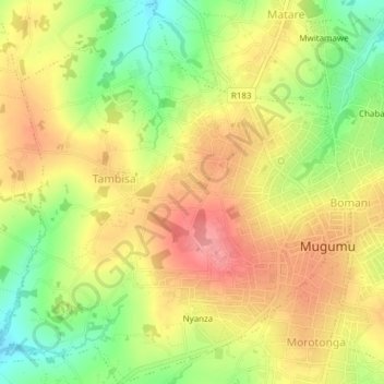
Name: Mugumu topographic map, elevation, terrain.
Location: Mugumu, Serengeti, Lake Zone, Tanzania (-1.85346 34.64066 -1.81544 34.67643)
Average elevation: 1,602 m
Minimum elevation: 1,549 m
Maximum elevation: 1,644 m
Thank you for supporting this site ❤️
Make a donation
Make a donation
Gear up for your next adventure:
As an Amazon Associate, this site earns from qualifying purchases at no extra cost to you.