
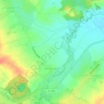
Wolfersdorf topographic map
Interactive map
Click on the map to display elevation.
About this map
Name: Wolfersdorf topographic map, elevation, terrain.
Average elevation: 304 m
Minimum elevation: 285 m
Maximum elevation: 332 m
Other topographic maps
Click on a map to view its topography, its elevation and its terrain.
Bettlach
Frankreich > Grand Est > Oberelsass
Bettlach, Altkirch, Oberelsass, Grand Est, Metropolitanes Frankreich, 68480, Frankreich
Average elevation: 469 m
Kirchberg
Frankreich > Grand Est > Oberelsass
Kirchberg, Thann-Gebweiler, Oberelsass, Grand Est, Metropolitanes Frankreich, 68290, Frankreich
Average elevation: 614 m
Blotzheim
Frankreich > Grand Est > Oberelsass
Blotzheim, Mülhausen, Oberelsass, Grand Est, Metropolitanes Frankreich, 68730, Frankreich
Average elevation: 281 m
Sternenberg
Frankreich > Grand Est > Oberelsass
Sternenberg, Altkirch, Oberelsass, Grand Est, Metropolitanes Frankreich, 68780, Frankreich
Average elevation: 335 m
Schlierbach
Frankreich > Grand Est > Oberelsass
Schlierbach, Mülhausen, Oberelsass, Grand Est, Metropolitanes Frankreich, 68440, Frankreich
Average elevation: 276 m
Walheim
Frankreich > Grand Est > Oberelsass
Walheim, Altkirch, Oberelsass, Grand Est, Metropolitanes Frankreich, 68130, Frankreich
Average elevation: 324 m
Zell
Frankreich > Grand Est > Oberelsass
Zell, Colmar-Rappoltsweiler, Oberelsass, Grand Est, Metropolitanes Frankreich, 68910, Frankreich
Average elevation: 659 m
Fessenheim
Frankreich > Grand Est > Oberelsass
Fessenheim, Colmar-Rappoltsweiler, Oberelsass, Grand Est, Metropolitanes Frankreich, 68740, Frankreich
Average elevation: 208 m
Murbach
Frankreich > Grand Est > Oberelsass
Murbach, Thann-Gebweiler, Oberelsass, Grand Est, Metropolitanes Frankreich, 68530, Frankreich
Average elevation: 612 m
Urbeis
Frankreich > Grand Est > Oberelsass
Urbeis, Colmar-Rappoltsweiler, Oberelsass, Grand Est, Metropolitanes Frankreich, 68370, Frankreich
Average elevation: 730 m
Rufach
Frankreich > Grand Est > Oberelsass
Rufach, Thann-Gebweiler, Oberelsass, Grand Est, Metropolitanes Frankreich, 68250, Frankreich
Average elevation: 292 m
Mittlach
Frankreich > Grand Est > Oberelsass
Mittlach, Colmar-Rappoltsweiler, Oberelsass, Grand Est, Metropolitanes Frankreich, 68380, Frankreich
Average elevation: 862 m