
Maur topographic map
Interactive map
Click on the map to display elevation.
About this map
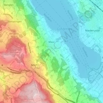
Name: Maur topographic map, elevation, terrain.
Location: Maur, Bezirk Uster, Zurich, Switzerland (47.30829 8.62129 47.36212 8.69778)
Average elevation: 544 m
Minimum elevation: 432 m
Maximum elevation: 780 m
Other topographic maps
Click on a map to view its topography, its elevation and its terrain.
Binz
Switzerland > Zurich > Bezirk Uster
Binz, Maur, Bezirk Uster, Zurich, 8122, Switzerland
Average elevation: 592 m
Gutenswil
Switzerland > Zurich > Bezirk Uster > Volketswil
Gutenswil, Volketswil, Bezirk Uster, Zurich, 8605, Switzerland
Average elevation: 519 m
Wangen
Switzerland > Zurich > Bezirk Uster > Wangen-Brüttisellen > Wangen
Wangen, Wangen-Brüttisellen, Bezirk Uster, Zurich, 8602, Switzerland
Average elevation: 465 m