
Make a donation
Gear up for your next adventure:
As an Amazon Associate, this site earns from qualifying purchases at no extra cost to you.
Binz topographic map
Click on the map to display elevation.
Make a donation
Gear up for your next adventure:
As an Amazon Associate, this site earns from qualifying purchases at no extra cost to you.
About this map
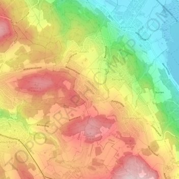
Name: Binz topographic map, elevation, terrain.
Location: Binz, Maur, Bezirk Uster, Zurich, 8122, Switzerland (47.33732 8.60678 47.37732 8.64678)
Average elevation: 592 m
Minimum elevation: 431 m
Maximum elevation: 728 m
Make a donation
Gear up for your next adventure:
As an Amazon Associate, this site earns from qualifying purchases at no extra cost to you.
Other topographic maps
Click on a map to view its topography, its elevation and its terrain.
Egg
Switzerland > Zurich > Bezirk Uster
The lowest elevation in the municipality is the Greifensee at 438 m (1,437 ft). The highest point in the municipality is the Pfannenstiel at 853 m (2,799 ft).
Average elevation: 581 m