Geolocate

Rengas topographic map

Click on the map to display elevation.

About this map

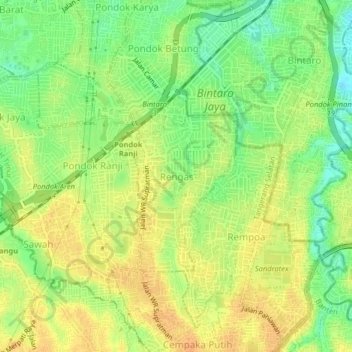
Name: Rengas topographic map, elevation, terrain.

Location: Rengas, South Tangerang, Banten, 15412, Indonesia (-6.30145 106.73023 -6.26145 106.77023)

Average elevation: 36 m

Minimum elevation: 17 m

Maximum elevation: 49 m

Other topographic maps

Click on a map to view its topography, its elevation and its terrain.

Parigi Baru

Indonesia > Banten > South Tangerang

Average elevation: 29 m

Setu

Indonesia > Banten > South Tangerang

Average elevation: 51 m

Kademangan

Indonesia > Banten > South Tangerang

Average elevation: 46 m

Provence Suites

Indonesia > Banten > South Tangerang

Average elevation: 34 m

Taman Provence

Indonesia > Banten > South Tangerang

Average elevation: 34 m

Pondok Pucung

Indonesia > Banten > South Tangerang

Average elevation: 35 m

Pondok Karya

Indonesia > Banten > South Tangerang

Average elevation: 30 m

Ciater

Indonesia > Banten > South Tangerang

Average elevation: 42 m

Babakan

Indonesia > Banten > South Tangerang

Average elevation: 60 m

Jelupang

Indonesia > Banten > South Tangerang

Average elevation: 30 m

Jombang

Indonesia > Banten > South Tangerang

Average elevation: 40 m

Gear up for your next adventure:

🔦Outdoor Torches - Reliable torches for night navigation
🚶Walking Pedometers - Simple distance tracking for casual trail walkers
🛑Emergency Bivvy Bags - Heat-reflective survival bags for unexpected nights out
🥤Hiking Water Bottles - Reusable bottles for hydration on the trail
🧥Breathable Waterproof Jackets - Essential rain protection for the unpredictable British climate

As an Amazon Associate, this site earns from qualifying purchases at no extra cost to you.