
Make a donation
Gear up for your next adventure:
As an Amazon Associate, this site earns from qualifying purchases at no extra cost to you.
Nesh topographic map
Click on the map to display elevation.
Make a donation
Gear up for your next adventure:
As an Amazon Associate, this site earns from qualifying purchases at no extra cost to you.
About this map
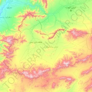
Name: Nesh topographic map, elevation, terrain.
Location: Nesh, Kandahar Province, Afghanistan (32.22002 65.42367 32.58691 66.03348)
Average elevation: 1,671 m
Minimum elevation: 1,031 m
Maximum elevation: 2,711 m
Make a donation
Gear up for your next adventure:
As an Amazon Associate, this site earns from qualifying purchases at no extra cost to you.
Other topographic maps
Click on a map to view its topography, its elevation and its terrain.
Kandahar
Afghanistan > Kandahar Province > Kandahar
Kandahar (English: /ˈkændəhɑːr/; Pashto: کندهار Kandahār, Dari: قندهار, Qandahār) is a city in Afghanistan, located in the south of the country on the Arghandab River, at an elevation of 1,010 m (3,310 ft). It is Afghanistan's second largest city after Kabul, with a population of about…
Average elevation: 1,048 m
Kandahar
Afghanistan > Kandahar Province > Kandahar
Kandahar (English: /ˈkændəhɑːr/; Pashto: کندهار, romanized: kandahār; Dari: قندهار, romanized: qandahār) is a city in Afghanistan, located in the south of the country on the Arghandab River, at an elevation of 1,010 m (3,310 ft). It is Afghanistan's second largest city after Kabul, with a…
Average elevation: 1,048 m
Kandahar
Afghanistan > Kandahar Province > Kandahar
Kandahar is a city in Afghanistan, located in the south of the country on Arghandab River, at an elevation of 1,010 m (3,310 ft). It is Afghanistan's second largest city, after Kabul, with a population of about 614,118 in 2015. It is the capital of Kandahar Province and the centre of the larger cultural region…
Average elevation: 1,048 m
Kandahar
Afghanistan > Kandahar Province > Kandahar
Kandahar (Pashto: کندهار; Dari: قندهار), is a city in Afghanistan, located in the south of the country on Arghandab River, at an elevation of 1,010 m (3,310 ft). It is Afghanistan's second largest city, after Kabul, with a population of about 614,118 in 2015. It is the capital of Kandahar Province…
Average elevation: 1,048 m
Make a donation
Gear up for your next adventure:
As an Amazon Associate, this site earns from qualifying purchases at no extra cost to you.