Geolocate

Rhos topographic map

Click on the map to display elevation.

About this map

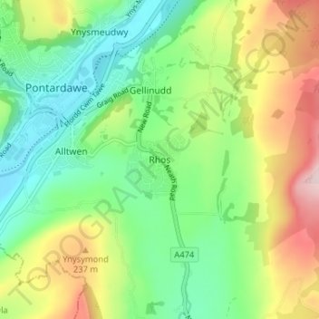
Name: Rhos topographic map, elevation, terrain.

Location: Rhos, Neath Port Talbot, Wales, SA8 3EQ, United Kingdom (51.69291 -3.84792 51.73291 -3.80792)

Average elevation: 139 m

Minimum elevation: 25 m

Maximum elevation: 340 m

Neath Port Talbot trails, hiking, mountain biking, running and outdoor activities

Other topographic maps

Click on a map to view its topography, its elevation and its terrain.

River Neath

United Kingdom > Wales > Neath Port Talbot > Resolven

Average elevation: 272 m

Glynneath

United Kingdom > Wales > Neath Port Talbot

Average elevation: 246 m

Cilybebyll

United Kingdom > Wales > Neath Port Talbot > Gellinudd

Average elevation: 179 m

Pelenna

United Kingdom > Wales > Neath Port Talbot

Average elevation: 217 m

Crynant

United Kingdom > Wales > Neath Port Talbot

Average elevation: 232 m

Neath

United Kingdom > Wales > Neath Port Talbot

Average elevation: 71 m

Pontardawe

United Kingdom > Wales > Neath Port Talbot

Average elevation: 180 m

Gear up for your next adventure:

🚶Walking Pedometers - Simple distance tracking for casual trail walkers
🧰First Aid Kits - Essential safety kits for outdoor activities
🧭Professional Hiking Compasses - High-precision liquid-filled compasses for map reading and orientation
🥤Hydration Bladders - Hands-free hydration systems for backpacks
🖼️Topographic Map Art - Decorative 3D-effect posters of famous UK peaks and regions

As an Amazon Associate, this site earns from qualifying purchases at no extra cost to you.