
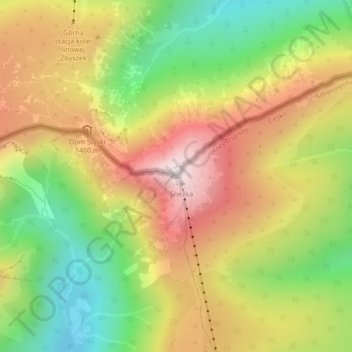
Śnieżka / Sněžka topographic map
Interactive map
Click on the map to display elevation.
About this map
Name: Śnieżka / Sněžka topographic map, elevation, terrain.
Average elevation: 1,262 m
Minimum elevation: 938 m
Maximum elevation: 1,596 m
Due to high altitude the climate is maritime polar (Köppen: ET) not far from a continental subpolar climate (Dfc). The difference should be at least 6 °C lower on annual average compared to the weather station in the plains.
Other topographic maps
Click on a map to view its topography, its elevation and its terrain.
Karpacz
Poland > Lower Silesian Voivodeship > Karkonosze County > Karpacz
Karpacz, Karkonosze County, Lower Silesian Voivodeship, 58-540, Poland
Average elevation: 933 m