
Qomrud RD topographic map
Interactive map
Click on the map to display elevation.
About this map
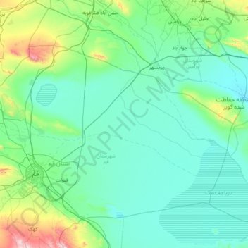
Name: Qomrud RD topographic map, elevation, terrain.
Average elevation: 923 m
Minimum elevation: 769 m
Maximum elevation: 2,224 m
Other topographic maps
Click on a map to view its topography, its elevation and its terrain.
Qom
Iran > Qom Province > Qom County
Qom, Qom Central District, Qom County, Qom Province, Iran
Average elevation: 943 m