Geolocate

Kilmacrennan topographic map

Click on the map to display elevation.

About this map

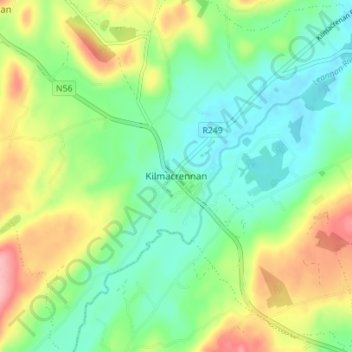
Name: Kilmacrennan topographic map, elevation, terrain.

Location: Kilmacrennan, County Donegal, Ireland (55.01052 -7.79921 55.05052 -7.75921)

Average elevation: 63 m

Minimum elevation: 19 m

Maximum elevation: 143 m

Gear up for your next adventure:

Lightweight Tents - Compact tents for backpacking and trekking
🧊Insulated Flasks - Keeps drinks hot or cold during hikes
🧤Thermal Touchscreen Gloves - Stay warm while operating your GPS or smartphone camera
🎒Hiking Child Carriers - Explore the outdoors with the whole family safely
🖼️Topographic Map Art - Decorative 3D-effect posters of famous UK peaks and regions

As an Amazon Associate, this site earns from qualifying purchases at no extra cost to you.