Geolocate

Samaguri topographic map

Click on the map to display elevation.

About this map

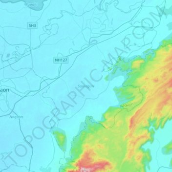
Name: Samaguri topographic map, elevation, terrain.

Location: Samaguri, Nagaon, Assam, India (26.21436 92.69993 26.49385 92.96541)

Average elevation: 139 m

Minimum elevation: 58 m

Maximum elevation: 843 m

Gear up for your next adventure:

🧺Microfibre Travel Towels - Fast-drying and compact towels for wild swimming and camping
🧥Softshell Jackets - Breathable jackets for active outdoor use
🖼️Topographic Map Art - Decorative 3D-effect posters of famous UK peaks and regions
🥤Collapsible Water Bottles - Save space in your rucksack as you consume your water
🛰️Satellite Messengers - Emergency communication devices for areas without mobile signal

As an Amazon Associate, this site earns from qualifying purchases at no extra cost to you.