Geolocate

Perlis River topographic map

Click on the map to display elevation.

About this map

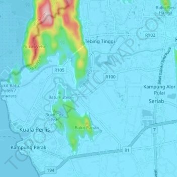
Name: Perlis River topographic map, elevation, terrain.

Location: Perlis River, Kangar, Perlis, 01000, Malaysia (6.40124 100.12862 6.43784 100.19885)

Average elevation: 23 m

Minimum elevation: -2 m

Maximum elevation: 316 m

Other topographic maps

Click on a map to view its topography, its elevation and its terrain.

Arau

Malaysia > Perlis > Kangar

Average elevation: 10 m

Bukit Lagi

Malaysia > Perlis > Kangar

Average elevation: 9 m

Kampung Kurong Tengar

Malaysia > Perlis > Kangar

Average elevation: 2 m

Sungai Tepoh

Malaysia > Perlis > Kangar

Average elevation: 6 m

Taman Sena Indah

Malaysia > Perlis > Kangar

Average elevation: 5 m

Gear up for your next adventure:

📱Rugged Phone Cases - Heavy-duty protection for smartphones used as secondary GPS tools
🛑Emergency Bivvy Bags - Heat-reflective survival bags for unexpected nights out
🌦️Portable Weather Meters - Handheld tools for monitoring weather conditions
📷Outdoor Action Cameras - Cameras designed for hiking and adventure
🌄Outdoor Binoculars - Compact binoculars for landscape observation

As an Amazon Associate, this site earns from qualifying purchases at no extra cost to you.