
Kiruhura topographic map
Interactive map
Click on the map to display elevation.
About this map
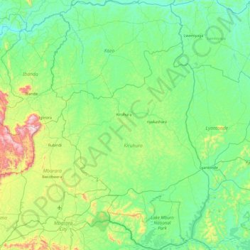
Name: Kiruhura topographic map, elevation, terrain.
Location: Kiruhura, Western Region, Uganda (-0.71227 30.56789 0.21405 31.15401)
Average elevation: 1,338 m
Minimum elevation: 1,141 m
Maximum elevation: 2,168 m
Other topographic maps
Click on a map to view its topography, its elevation and its terrain.
Lake Mburo
Uganda > Kiruhura > Lake Mburo Np
Lake Mburo, Lake Mburo Np, Kiruhura, Western Region, Uganda
Average elevation: 1,283 m