Geolocate

Kolar topographic map

Click on the map to display elevation.

Kolar

Kolar is located at 13°08′N 78°08′E / 13.13°N 78.13°E / 13.13; 78.13.[3] with an average elevation of 849 metres (2,785 ft).

Wikipedia (CC-BY-SA 3.0)

About this map

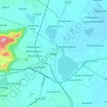
Name: Kolar topographic map, elevation, terrain.

Location: Kolar, Kolar taluk, Kolar District, Karnataka, 563101, India (12.97672 77.97372 13.29672 78.29372)

Average elevation: 847 m

Minimum elevation: 780 m

Maximum elevation: 1,221 m

Gear up for your next adventure:

🔦LED Camping Lanterns - Illumination for reading maps inside your tent at night
📕Outdoor Navigation Books - Learn traditional and modern navigation techniques
📱Rugged Phone Cases - Heavy-duty protection for smartphones used as secondary GPS tools
🧴Sport Sunscreen Sticks - High-protection sunblock that won't run into your eyes on the trail
🎒Replacement Sternum Straps - Repair parts for hiking rucksacks

As an Amazon Associate, this site earns from qualifying purchases at no extra cost to you.