Geolocate

Burke topographic map

Click on the map to display elevation.

About this map

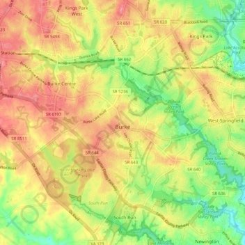
Name: Burke topographic map, elevation, terrain.

Location: Burke, Fairfax County, Virginia, 22015, United States (38.74530 -77.32718 38.81153 -77.22685)

Average elevation: 97 m

Minimum elevation: 50 m

Maximum elevation: 136 m

Gear up for your next adventure:

🧭GPS Trackers - Tracking devices for safety and navigation
🧗Locking Carabiners - Secure gear to your pack or for light technical use
🛌Insulated Sleeping Mats - Crucial thermal protection when sleeping on cold, uneven ground
🔦Head Torches - Hands-free lighting for hiking and camping
🔋Solar Power Banks - Keep your GPS and phone charged during multi-day expeditions

As an Amazon Associate, this site earns from qualifying purchases at no extra cost to you.