
Make a donation
Gear up for your next adventure:
As an Amazon Associate, this site earns from qualifying purchases at no extra cost to you.
Santa Rosa de Cabal topographic map
Click on the map to display elevation.
Make a donation
Gear up for your next adventure:
As an Amazon Associate, this site earns from qualifying purchases at no extra cost to you.
About this map
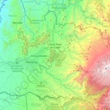
Name: Santa Rosa de Cabal topographic map, elevation, terrain.
Average elevation: 1,954 m
Minimum elevation: 841 m
Maximum elevation: 4,576 m
Make a donation
Gear up for your next adventure:
As an Amazon Associate, this site earns from qualifying purchases at no extra cost to you.
Other topographic maps
Click on a map to view its topography, its elevation and its terrain.
Santa Rosa de Cabal
Colombia > Risaralda > Santa Rosa de Cabal > Santa Rosa de Cabal
Average elevation: 1,769 m
Make a donation
Gear up for your next adventure:
As an Amazon Associate, this site earns from qualifying purchases at no extra cost to you.
Apía
Colombia > Risaralda > Apía > Apía
Apía is a town and municipality in the Department of Risaralda, Colombia. It is located at an elevation of 1,630 metres, about 60 km away from district capital Pereira in the valley of the Apia river. It has approximately 11,000 inhabitants according to the 2018 census. The town has excellent views over the…
Average elevation: 1,646 m