
Make a donation
Gear up for your next adventure:
As an Amazon Associate, this site earns from qualifying purchases at no extra cost to you.
Firwood topographic map
Click on the map to display elevation.
Make a donation
Gear up for your next adventure:
As an Amazon Associate, this site earns from qualifying purchases at no extra cost to you.
About this map
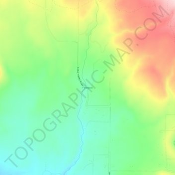
Name: Firwood topographic map, elevation, terrain.
Location: Firwood, Klickitat County, Washington, United States (45.91123 -120.93285 45.95123 -120.89285)
Average elevation: 760 m
Minimum elevation: 653 m
Maximum elevation: 926 m
Make a donation
Gear up for your next adventure:
As an Amazon Associate, this site earns from qualifying purchases at no extra cost to you.
Other topographic maps
Click on a map to view its topography, its elevation and its terrain.
Goldendale
United States > Washington > Klickitat County
Goldendale's elevation at the County Courthouse is 498 meters (1,634 feet).
Average elevation: 514 m
Columbia River Gorge National Scenic Area
United States > Washington > Klickitat County
The Columbia River, Klamath River in northern California, Pit River in northern California, and Fraser River in southern British Columbia are the only four rivers connecting the watersheds on the east side of the Cascade Range to the Pacific Ocean. Each river has carved out a gorge through the Cascades. The…
Average elevation: 723 m
Make a donation
Gear up for your next adventure:
As an Amazon Associate, this site earns from qualifying purchases at no extra cost to you.
Observatory Hill State Park
United States > Washington > Klickitat County > Goldendale
Average elevation: 540 m
Make a donation
Gear up for your next adventure:
As an Amazon Associate, this site earns from qualifying purchases at no extra cost to you.
Goldendale
United States > Washington > Klickitat County
Goldendale's elevation at the County Courthouse is 498 meters (1,634 feet).
Average elevation: 514 m
Make a donation
Gear up for your next adventure:
As an Amazon Associate, this site earns from qualifying purchases at no extra cost to you.