
Jelenia Góra topographic map
Interactive map
Click on the map to display elevation.
About this map
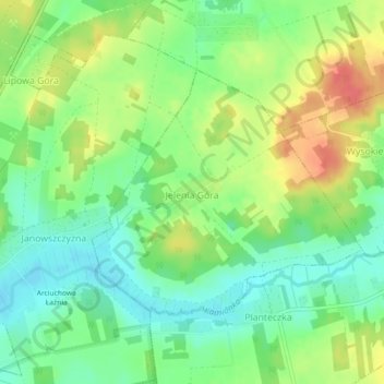
Name: Jelenia Góra topographic map, elevation, terrain.
Average elevation: 166 m
Minimum elevation: 142 m
Maximum elevation: 198 m
Other topographic maps
Click on a map to view its topography, its elevation and its terrain.
Dąbrowa Białostocka
Poland > Podlaskie Voivodeship > Sokółka County
Dąbrowa Białostocka, gmina Dąbrowa Białostocka, Sokółka County, Podlaskie Voivodeship, 16-200, Poland
Average elevation: 153 m
Ostra Góra
Poland > Podlaskie Voivodeship > Sokółka County > Ostra Góra
Ostra Góra, gmina Korycin, Sokółka County, Podlaskie Voivodeship, Poland
Average elevation: 166 m
Stock
Poland > Podlaskie Voivodeship > Sokółka County
Stock, gmina Dąbrowa Białostocka, Sokółka County, Podlaskie Voivodeship, Poland
Average elevation: 151 m
Sokółka
Poland > Podlaskie Voivodeship > Sokółka County
Sokółka, gmina Sokółka, Sokółka County, Podlaskie Voivodeship, 16-100, Poland
Average elevation: 167 m
Popiołówka
Poland > Podlaskie Voivodeship > Sokółka County
Popiołówka, gmina Korycin, Sokółka County, Podlaskie Voivodeship, Poland
Average elevation: 149 m