
Departamento Libertad topographic map
Interactive map
Click on the map to display elevation.
About this map
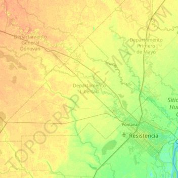
Name: Departamento Libertad topographic map, elevation, terrain.
Location: Departamento Libertad, CCO, Argentinien (-27.46880 -59.58285 -27.15075 -58.97174)
Average elevation: 58 m
Minimum elevation: 43 m
Maximum elevation: 73 m
Other topographic maps
Click on a map to view its topography, its elevation and its terrain.
América
Argentinien > CCO > Resistencia
América, Resistencia, Departamento San Fernando, CCO, Argentinien
Average elevation: 53 m