
Thank you for supporting this site ❤️
Make a donation
Make a donation
Gear up for your next adventure:
As an Amazon Associate, this site earns from qualifying purchases at no extra cost to you.
Kıraç topographic map
Click on the map to display elevation.
Thank you for supporting this site ❤️
Make a donation
Make a donation
Gear up for your next adventure:
As an Amazon Associate, this site earns from qualifying purchases at no extra cost to you.
About this map
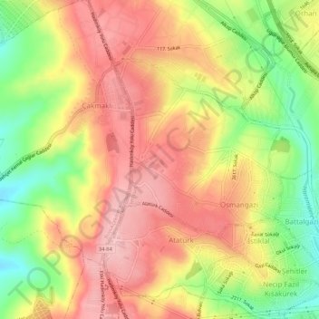
Name: Kıraç topographic map, elevation, terrain.
Location: Kıraç, Esenyurt, Istanbul, Marmara Region, 34522, Turkey (41.02714 28.61268 41.06714 28.65268)
Average elevation: 132 m
Minimum elevation: 43 m
Maximum elevation: 198 m
Thank you for supporting this site ❤️
Make a donation
Make a donation
Gear up for your next adventure:
As an Amazon Associate, this site earns from qualifying purchases at no extra cost to you.