
Dalton topographic map
Click on the map to display elevation.
About this map
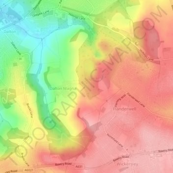
Name: Dalton topographic map, elevation, terrain.
Location: Dalton, Rotherham, South Yorkshire, England, United Kingdom (53.41952 -1.31935 53.44685 -1.27102)
Average elevation: 100 m
Minimum elevation: 22 m
Maximum elevation: 148 m
England trails, hiking, mountain biking, running and outdoor activities
Other topographic maps
Click on a map to view its topography, its elevation and its terrain.
Kiveton Park
United Kingdom > England > Rotherham
Kiveton Park is located at approximately 53°20′30″N 1°15′30″W / 53.34167°N 1.25833°W / 53.34167; -1.25833, at an elevation of around 330 feet (100 m) above sea level, and is located 8 miles (13 km) west of Worksop, and 11 miles (18 km) south-east of both Sheffield, and Rotherham…
Average elevation: 104 m
Treeton
United Kingdom > England > Rotherham
Catcliffe Flash, to the west of the village, is a local nature reserve that is made up of a lake and marshland formed as the elevation of the land beside the River Rother dropped due to coal mining subsidence. To the south-east of the village are three areas of ancient woodland, Treeton Wood, Hail Mary Hill…
Average elevation: 58 m
Catcliffe
United Kingdom > England > Rotherham
The Catcliffe Glass Cone, part of the previous William Fenney's glassworks, is on Main Street. The centre of the village is dominated by a nine-arch viaduct that was built in 1901 to carry the Sheffield District Railway across the River Rother. Catcliffe Flash, to the south of the village, is a local nature…
Average elevation: 58 m
Sheffield and South Yokshire Navigation
United Kingdom > England > Rotherham > Thrybergh
Average elevation: 39 m