
Thank you for supporting this site ❤️
Make a donation
Make a donation
Gear up for your next adventure:
As an Amazon Associate, this site earns from qualifying purchases at no extra cost to you.
Lekidthang topographic map
Click on the map to display elevation.
Thank you for supporting this site ❤️
Make a donation
Make a donation
Gear up for your next adventure:
As an Amazon Associate, this site earns from qualifying purchases at no extra cost to you.
About this map
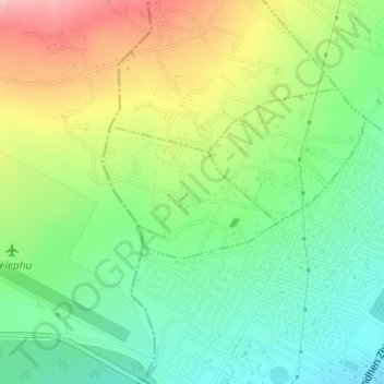
Name: Lekidthang topographic map, elevation, terrain.
Location: Lekidthang, Gelegphu Gewog, Sarpang District, Bhutan (26.88694 90.46864 26.89626 90.48246)
Average elevation: 296 m
Minimum elevation: 234 m
Maximum elevation: 391 m
Thank you for supporting this site ❤️
Make a donation
Make a donation
Gear up for your next adventure:
As an Amazon Associate, this site earns from qualifying purchases at no extra cost to you.