
Poiana Mărului topographic map
Interactive map
Click on the map to display elevation.
About this map
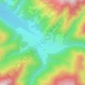
Name: Poiana Mărului topographic map, elevation, terrain.
Location: Poiana Mărului, Zăvoi, Caraș-Severin, 327439, Romania (45.38328 22.52071 45.42328 22.56071)
Average elevation: 867 m
Minimum elevation: 578 m
Maximum elevation: 1,331 m
Other topographic maps
Click on a map to view its topography, its elevation and its terrain.
Băile Herculane
Băile Herculane (Latin: Aqua Herculis; German: Herkulesbad; Hungarian: Herkulesfürdő; Czech: Herkulovy Lázně, Turkish: Lazarethane) is a spa town in Romanian Banat, in Caraș-Severin County, situated in the valley of the Cerna River, between the Mehedinți Mountains to the east and the Cerna Mountains to…
Average elevation: 571 m
Teregova
The commune is located in the east-central part of county, stretching eastwards to the border with Hunedoara County. It is situated at an altitude of 424 m (1,391 ft), at the foot of the Țarcu Mountains. The river Timiș flows through Rusca village; its right tributary, the river Teregova, joins the Timiș in…
Average elevation: 803 m