Geolocate

Streymoy topographic map

Interactive map

Click on the map to display elevation.

About this map

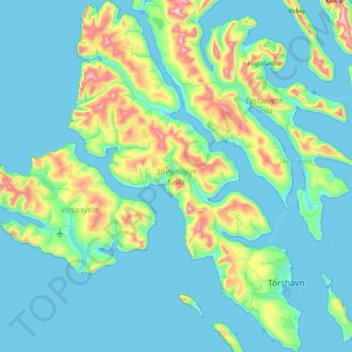
Name: Streymoy topographic map, elevation, terrain.

Location: Streymoy, Streymoy region, Faroe Islands (61.93813 -7.26072 62.30909 -6.73299)

Average elevation: 133 m

Minimum elevation: -7 m

Maximum elevation: 882 m

Other topographic maps

Click on a map to view its topography, its elevation and its terrain.

Tórshavn

Faroe Islands > Streymoy region

Tórshavn, Streymoy region, 100, Faroe Islands

Average elevation: 68 m

Streymoy

Faroe Islands > Streymoy region > Stykkið

Streymoy, Stykkið, Streymoy region, 330, Faroe Islands

Average elevation: 60 m

Válur

Faroe Islands > Streymoy region > Válur

Válur, Streymoy region, 358, Faroe Islands

Average elevation: 181 m

Hósvík

Faroe Islands > Streymoy region

Hósvík, Streymoy region, 420, Faroe Islands

Average elevation: 243 m