
Thank you for supporting this site ❤️
Make a donation
Make a donation
Gear up for your next adventure:
As an Amazon Associate, this site earns from qualifying purchases at no extra cost to you.
Calbuco topographic map
Click on the map to display elevation.
Thank you for supporting this site ❤️
Make a donation
Make a donation
Gear up for your next adventure:
As an Amazon Associate, this site earns from qualifying purchases at no extra cost to you.
About this map
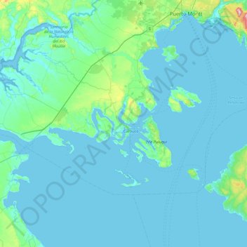
Name: Calbuco topographic map, elevation, terrain.
Location: Calbuco, Provincia de Llanquihue, Los Lagos Region, Chile (-41.93353 -73.54571 -41.57179 -72.70124)
Average elevation: 29 m
Minimum elevation: -1 m
Maximum elevation: 720 m
Thank you for supporting this site ❤️
Make a donation
Make a donation
Gear up for your next adventure:
As an Amazon Associate, this site earns from qualifying purchases at no extra cost to you.
Other topographic maps
Click on a map to view its topography, its elevation and its terrain.
Mirador de Puerto Varas
Chile > Los Lagos Region > Provincia de Llanquihue > Puerto Varas
Average elevation: 112 m