
Alverna topographic map
Interactive map
Click on the map to display elevation.
About this map
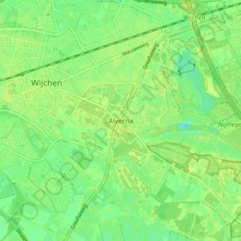
Name: Alverna topographic map, elevation, terrain.
Location: Alverna, Wijchen, Gelderland, Nederland, 6603 CM, Nederland (51.78350 5.73618 51.82350 5.77618)
Average elevation: 10 m
Minimum elevation: 1 m
Maximum elevation: 15 m
Other topographic maps
Click on a map to view its topography, its elevation and its terrain.
Klispoel
Nederland > Gelderland > Wijchen
Klispoel, Wijchen, Gelderland, Nederland, 6602 ND, Nederland
Average elevation: 9 m
Woezikrot
Nederland > Gelderland > Wijchen
Woezikrot, Wijchen, Gelderland, Nederland, 6604 BW, Nederland
Average elevation: 9 m
Hoogbroek
Nederland > Gelderland > Wijchen > Alverna
Hoogbroek, Alverna, Wijchen, Gelderland, Nederland, 6603 KE, Nederland
Average elevation: 10 m
Balgoij
Nederland > Gelderland > Wijchen
Balgoij, Wijchen, Gelderland, Nederland
Average elevation: 9 m
Hernen
Nederland > Gelderland > Wijchen > Hernen
Hernen, Dorpsstraat, Hernen, Wijchen, Gelderland, Nederland, 6616BE, Nederland
Average elevation: 8 m