
Zernez topographic map
Interactive map
Click on the map to display elevation.
Zernez
Lai da Ova Spin is a compensation reservoir on the river Spöl. It is located in the upper areas of the Lower Engadine valley (Romansh: Engiadina Bassa). It is located at an elevation of 1,473 m (4,833 ft) and is connected to the railway network of the Rhätische Bahn. In Zernez, the stream Spöl empties into the Inn (Romansh: En).
About this map
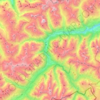
Name: Zernez topographic map, elevation, terrain.
Average elevation: 2,297 m
Minimum elevation: 1,199 m
Maximum elevation: 3,366 m
Other topographic maps
Click on a map to view its topography, its elevation and its terrain.
Piz Linard
Switzerland > Grisons > Region Engiadina Bassa/Val Müstair > Zernez
Average elevation: 2,626 m
Fuorcla Val Sassa
Switzerland > Grisons > Region Engiadina Bassa/Val Müstair > Zernez
Average elevation: 2,698 m
Piz Vadret
Switzerland > Grisons > Region Engiadina Bassa/Val Müstair > Zernez
Piz Vadret is a mountain of the Albula Alps, in Graubünden. With an altitude of 3,229 metres above sea level, Piz Vadret is the highest mountain of the Albula Alps north of Piz Kesch. At the base of the north face lies a glacier named Vadret da Grialetsch. The closest locality is Brail, in the Engadin.
Average elevation: 2,824 m
Val Sinestra
Switzerland > Grisons > Region Engiadina Bassa/Val Müstair > Scuol
Average elevation: 1,966 m