
Make a donation
Gear up for your next adventure:
As an Amazon Associate, this site earns from qualifying purchases at no extra cost to you.
Miharati topographic map
Click on the map to display elevation.
Make a donation
Gear up for your next adventure:
As an Amazon Associate, this site earns from qualifying purchases at no extra cost to you.
About this map
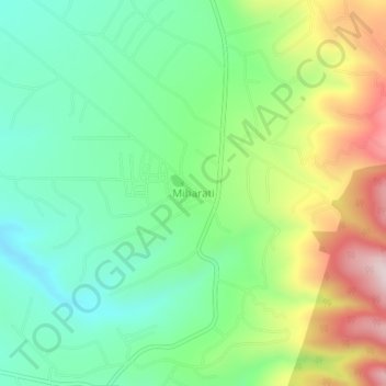
Name: Miharati topographic map, elevation, terrain.
Location: Miharati, Kipipiri, Nyandarua, 20301, Kenya (-0.41866 36.47297 -0.37866 36.51297)
Average elevation: 2,451 m
Minimum elevation: 2,290 m
Maximum elevation: 2,748 m
Make a donation
Gear up for your next adventure:
As an Amazon Associate, this site earns from qualifying purchases at no extra cost to you.
Other topographic maps
Click on a map to view its topography, its elevation and its terrain.
Malewa
The Malewa River catchment of 1,730 square kilometres (670 sq mi) provides about 90% of the water flowing into Lake Naivasha, with most of the remainder coming from the Gilgil River. The headwaters of the main channel of the Malewa originate at an elevation of 3,700 metres (12,100 ft) in the Nyandarua…
Average elevation: 2,322 m