
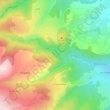
Ruille topographic map
Interactive map
Click on the map to display elevation.
About this map
Name: Ruille topographic map, elevation, terrain.
Average elevation: 600 m
Minimum elevation: 435 m
Maximum elevation: 808 m
Other topographic maps
Click on a map to view its topography, its elevation and its terrain.
Chambrelin
France > Auvergne-Rhône-Alpes > Châtelneuf
Chambrelin, Châtelneuf, Montbrison, Loire, Auvergne-Rhône-Alpes, France métropolitaine, 42940, France
Average elevation: 772 m
Mont Semiol
France > Auvergne-Rhône-Alpes > Châtelneuf
Mont Semiol, Châtelneuf, Montbrison, Loire, Auvergne-Rhône-Alpes, France métropolitaine, 42940, France
Average elevation: 856 m