
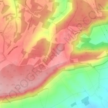
Holly Hill Wood topographic map
Interactive map
Click on the map to display elevation.
About this map
Name: Holly Hill Wood topographic map, elevation, terrain.
Average elevation: 137 m
Minimum elevation: 38 m
Maximum elevation: 197 m
Other topographic maps
Click on a map to view its topography, its elevation and its terrain.
East Malling and Larkfield
United Kingdom > England > Tonbridge and Malling
East Malling and Larkfield, Tonbridge and Malling, Kent, South East, England, United Kingdom
Average elevation: 40 m
Wrotham
United Kingdom > England > Tonbridge and Malling > Wrotham
Wrotham, Tonbridge and Malling, Kent, South East England, England, TN15 7DR, United Kingdom
Average elevation: 144 m
Shipbourne
United Kingdom > England > Tonbridge and Malling > Shipbourne
Shipbourne, Tonbridge and Malling, Kent, South East, England, TN11 9PE, United Kingdom
Average elevation: 80 m