
Le Paradis topographic map
Interactive map
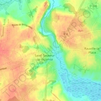
Click on the map to display elevation.
About this map
Name: Le Paradis topographic map, elevation, terrain.
Average elevation: 26 m
Minimum elevation: -1 m
Maximum elevation: 49 m
Other topographic maps
Click on a map to view its topography, its elevation and its terrain.
Selsoif
France > Normandie > Manche > Saint-Sauveur-le-Vicomte
Selsoif, Saint-Sauveur-le-Vicomte, Cherbourg, Manche, Normandie, France métropolitaine, 50390, France
Average elevation: 11 m
Voie Verte
France > Normandie > Manche > Saint-Sauveur-le-Vicomte > Les Closerons
Voie Verte, Chemin rural dit des Closerons, Les Closerons, Saint-Sauveur-le-Vicomte, Cherbourg, Manche, Normandie, France métropolitaine, 50390, France
Average elevation: 23 m
Les Closerons
France > Normandie > Manche > Saint-Sauveur-le-Vicomte
Les Closerons, Saint-Sauveur-le-Vicomte, Cherbourg, Manche, Normandie, France métropolitaine, 50390, France
Average elevation: 28 m
Le Planitre
France > Normandie > Manche > Saint-Sauveur-le-Vicomte
Le Planitre, Saint-Sauveur-le-Vicomte, Cherbourg, Manche, Normandie, France métropolitaine, 50390, France
Average elevation: 36 m