
Make a donation
Gear up for your next adventure:
As an Amazon Associate, this site earns from qualifying purchases at no extra cost to you.
Les Crosets topographic map
Click on the map to display elevation.
Make a donation
Gear up for your next adventure:
As an Amazon Associate, this site earns from qualifying purchases at no extra cost to you.
About this map
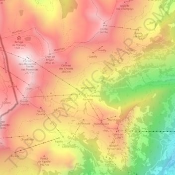
Name: Les Crosets topographic map, elevation, terrain.
Location: Les Crosets, Val-d'Illiez, Monthey, Valais, 1873, Suisse (46.16512 6.81568 46.20512 6.85568)
Average elevation: 1,773 m
Minimum elevation: 1,017 m
Maximum elevation: 2,262 m
Make a donation
Gear up for your next adventure:
As an Amazon Associate, this site earns from qualifying purchases at no extra cost to you.
Other topographic maps
Click on a map to view its topography, its elevation and its terrain.
Lac Vert
Suisse > Valais > Monthey > Val-d'Illiez
C'est un petit lac de montagne situé à 1 971 mètres d'altitude, à proximité de la frontière française.
Average elevation: 1,932 m
Lac Vert
Suisse > Valais > Monthey > Val-d'Illiez
C'est un petit lac de montagne situé à 1 971 mètres d'altitude, à proximité de la frontière française.
Average elevation: 1,932 m
Dents du Midi
Suisse > Valais > Monthey > Val-d'Illiez
Les dents du Midi se situent à la limite entre les communes de Val-d'Illiez et d'Evionnaz. La face nord s'élève au-dessus du val d'Illiez tandis que la face sud domine le lac de Salanfe. La crête du chaînon se situe à une altitude variant entre 2 997 mètres et 3 257 mètres ; elle est visible depuis…
Average elevation: 2,440 m