Geolocate

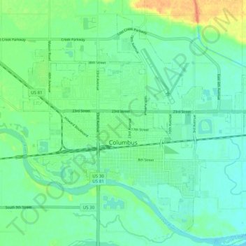
Columbus topographic map

Click on the map to display elevation.

Columbus

The city lies at an elevation of 1,447 feet (441 m). It is built on the flat terrain of the Platte River valley; rolling hills rise to the north of the city.

Wikipedia (CC-BY-SA 3.0)

About this map

Name: Columbus topographic map, elevation, terrain.

Location: Columbus, Platte County, Nebraska, United States (41.40238 -97.39830 41.46771 -97.29998)

Average elevation: 442 m

Minimum elevation: 431 m

Maximum elevation: 469 m

Other topographic maps

Click on a map to view its topography, its elevation and its terrain.
Oconee

United States > Nebraska > Platte County

Average elevation: 456 m

Gear up for your next adventure:

📐Altimeters & Barometers - Tools for measuring altitude and air pressure
🔦LED Camping Lanterns - Illumination for reading maps inside your tent at night
🌂Windproof Trekking Umbrellas - Surprising but effective rain protection on low-wind trails
🪢Paracord - Multi-purpose cord for camping and survival
🧤Hiking Gloves - Warm and durable gloves for cold-weather walks

As an Amazon Associate, this site earns from qualifying purchases at no extra cost to you.